
Tropical Storm Erin Graphics
5-Day Uncertainty Track last updated Thu, 14 Aug 2025 14:36:56 GMT Wind Speed Probabilities last updated Thu, 14 Aug 2025 15:22:38 GMT
Hiker made fatal mistake when encountering poisonous snake, officials believe

A hiker suffered a fatal snake bite in Tennessee after picking up a rattlesnake in Savage Gulf State Park, officials told Fox News Digital. Matthew Griffith of the Grundy County Emergency Management Agency said a Timber rattlesnake
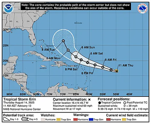
Tropical Storm Erin Public Advisory Number 13
Issued at 1100 AM AST Thu Aug 14 2025 341 WTNT35 KNHC 141435 TCPAT5 BULLETIN Tropical Storm Erin Advisory Number 13 NWS National Hurricane Center Miami FL AL052025 1100 AM AST Thu Aug 14 2025 …ERIN STRENGTHENING
Summary for Tropical Storm Erin (AT5/AL052025)
…ERIN STRENGTHENING WHILE MOVING WESTWARD… …FORECAST TO BECOME A HURRICANE BY TOMORROW… As of 11:00 AM AST Thu Aug 14 the center of Erin was located near 16.4, -49.7 with movement W at 17 mph. The minimum
Tropical Storm Erin Wind Speed Probabilities Number 13
Issued at 1500 UTC THU AUG 14 2025 334 FONT15 KNHC 141435 PWSAT5 TROPICAL STORM ERIN WIND SPEED PROBABILITIES NUMBER 13 NWS NATIONAL HURRICANE CENTER MIAMI FL AL052025 1500 UTC THU AUG 14 2025 AT 1500Z THE
Tropical Storm Erin Forecast Discussion Number 13
Issued at 1100 AM AST Thu Aug 14 2025 180 WTNT45 KNHC 141434 TCDAT5 Tropical Storm Erin Discussion Number 13 NWS National Hurricane Center Miami FL AL052025 1100 AM AST Thu Aug 14 2025 Satellite imagery shows
Significant resources deployed in Wyoming hunt for hiker who disappeared in ‘unforgiving’ Bighorn Mountains

Significant resources have been deployed amid the search effort for Grant Gardner, according to an Aug. 11 post on the Big Horn County Wyoming Sheriff’s Office Facebook page about the Minnesota man who went missing while hiking
American accused of faking death, fleeing US found guilty of raping former girlfriend

A man accused of faking his death and fleeing the country to avoid facing sexual assault charges was convicted Wednesday of first-degree felony rape. The verdict in the 2008 rape case came after a three-day trial in
Blue cities in Trump’s crosshairs after DC police takeover

As President Donald Trump looks to crack down on crime within Washington, D.C., by sending in federal law enforcement to patrol the city, data reveals the nation’s capital is plagued by violent crime when compared to other
Atlantic Tropical Weather Outlook
007 ABNT20 KNHC 141139TWOAT Tropical Weather OutlookNWS National Hurricane Center Miami FL800 AM EDT Thu Aug 14 2025 For the North Atlantic…Caribbean Sea and the Gulf of America: Active Systems:The National Hurricane Center is issuing advisories on