
Tennis legend Monica Seles reveals myasthenia gravis diagnosis

Tennis legend Monica Seles, 51, is speaking out about her diagnosis of myasthenia gravis (also known as MG); a rare, chronic neuromuscular autoimmune disease she was diagnosed with three years ago. The nine-time Grand Slam champion and
Wild rabbits spotted with strange ‘horn-like’ growths sprouting from their heads

Recently, some wild rabbits have been seen in the U.S. with “horn-like” growths spurting from their heads that are caused by a viral infection, according to experts. “Rabbit papillomas are growths on the skin caused by the cottontail
Tropical Storm Erin Graphics
5-Day Uncertainty Track last updated Wed, 13 Aug 2025 08:45:56 GMT Wind Speed Probabilities last updated Wed, 13 Aug 2025 09:21:37 GMT
Julia Garner, Anthony Boyle to star in Netflix limited series ‘The Altruists’

Variety has learned that Anthony Boyle will star opposite Julia Garner in a Netflix limited series about the rise and fall of FTX titled “The Altruists.” Boyle will star as Sam Bankman-Fried in the series, while Garner
See Sydney Sweeney and Halsey in trailer for ‘Americana’

Halsey and Sydney Sweeney star in the first trailer for Americana, a neo-Western directed by Tony Tost that features an ensemble cast, including Paul Walter Hauser, Simon Rex, Eric Dane and Zahn McClarnon. The film is set
Tropical Storm Erin Forecast Discussion Number 8
Issued at 500 AM AST Wed Aug 13 2025 000 WTNT45 KNHC 130843 TCDAT5 Tropical Storm Erin Discussion Number 8 NWS National Hurricane Center Miami FL AL052025 500 AM AST Wed Aug 13 2025 Deep convection is
Tropical Storm Erin Wind Speed Probabilities Number 8
Issued at 0900 UTC WED AUG 13 2025 000 FONT15 KNHC 130842 PWSAT5 TROPICAL STORM ERIN WIND SPEED PROBABILITIES NUMBER 8 NWS NATIONAL HURRICANE CENTER MIAMI FL AL052025 0900 UTC WED AUG 13 2025 AT 0900Z THE
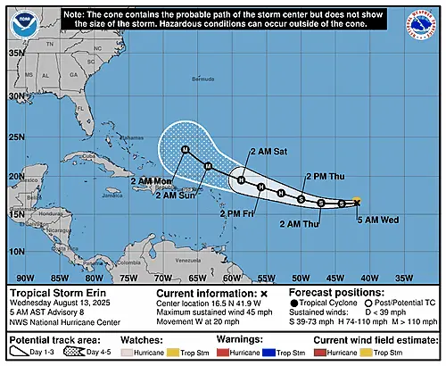
Summary for Tropical Storm Erin (AT5/AL052025)
…ERIN CONTINUES WESTWARD… …EXPECTED TO BECOME A HURRICANE IN A COUPLE OF DAYS… As of 5:00 AM AST Wed Aug 13 the center of Erin was located near 16.5, -41.9 with movement W at 20 mph. The
Tropical Storm Erin Public Advisory Number 8
Issued at 500 AM AST Wed Aug 13 2025 000 WTNT35 KNHC 130842 TCPAT5 BULLETIN Tropical Storm Erin Advisory Number 8 NWS National Hurricane Center Miami FL AL052025 500 AM AST Wed Aug 13 2025 …ERIN CONTINUES
Atlantic Tropical Weather Outlook
516 ABNT20 KNHC 130531TWOAT Tropical Weather OutlookNWS National Hurricane Center Miami FL200 AM EDT Wed Aug 13 2025 For the North Atlantic…Caribbean Sea and the Gulf of America: Active Systems:The National Hurricane Center is issuing advisories on