
American tourist shot and killed in Caribbean vacation hotspot: ‘Left an unfillable void in our lives’

A tourist from New York was killed while visiting Puerto Rico for a Bad Bunny concert, according to police. 25-year-old Kevin Mares was shot in the left side of his abdomen early Sunday morning in the La
Tropical Storm Erin Forecast Discussion Number 2
Issued at 500 PM AST Mon Aug 11 2025 000 WTNT45 KNHC 112248 CCA TCDAT5 Tropical Storm Erin Discussion Number 2…Corrected NWS National Hurricane Center Miami FL AL052025 500 PM AST Mon Aug 11 2025 Corrected spelling
911 calls, police report details dark timeline to Arizona girl’s tragic death

Editor’s note: The following story contains graphic descriptions. Recently released police documents have shed new light on the final weeks of 10-year-old Rebekah Baptiste’s life, revealing disturbing allegations of escalating abuse and multiple attempts to flee her
Tourist drowns in North Myrtle Beach
It was the second drowning death of the week in North Myrtle.
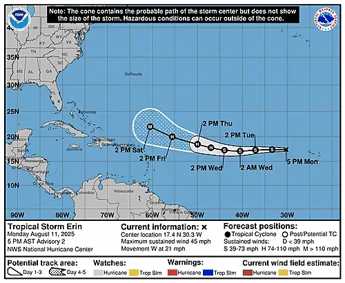
Tropical Storm Erin Graphics

5-Day Uncertainty Track last updated Mon, 11 Aug 2025 20:50:14 GMT Wind Speed Probabilities last updated Mon, 11 Aug 2025 21:22:15 GMT
Tropical Storm Erin Graphics
5-Day Uncertainty Track last updated Mon, 11 Aug 2025 20:50:14 GMT Wind Speed Probabilities last updated Mon, 11 Aug 2025 21:22:15 GMT
Tropical Storm Erin Forecast Discussion Number 2
Issued at 500 PM AST Mon Aug 11 2025 173 WTNT45 KNHC 112120 TCDAT5 Tropical Storm Erin Discussion Number 2 NWS National Hurricane Center Miami FL AL052025 500 PM AST Mon Aug 11 2025 Erin’s structure this
Tropical Storm Erin Wind Speed Probabilities Number 2
Issued at 2100 UTC MON AUG 11 2025 804 FONT15 KNHC 112044 PWSAT5 TROPICAL STORM ERIN WIND SPEED PROBABILITIES NUMBER 2 NWS NATIONAL HURRICANE CENTER MIAMI FL AL052025 2100 UTC MON AUG 11 2025 AT 2100Z THE
Tropical Storm Erin Public Advisory Number 2
Issued at 500 PM AST Mon Aug 11 2025 000 WTNT35 KNHC 112043 TCPAT5 BULLETIN Tropical Storm Erin Advisory Number 2 NWS National Hurricane Center Miami FL AL052025 500 PM AST Mon Aug 11 2025 …ERIN FORECAST
Summary for Tropical Storm Erin (AT5/AL052025)
…ERIN FORECAST TO BECOME A HURRICANE LATER THIS WEEK IN THE CENTRAL TROPICAL ATLANTIC… As of 5:00 PM AST Mon Aug 11 the center of Erin was located near 17.4, -30.3 with movement W at 21 mph.